


Reef snaps used to map time
 Print
Print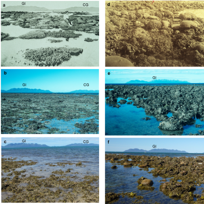 Experts have used historical photos to determine the timing of coral loss on the Great Barrier Reef.
The photos have proven to be a powerful visual tool for highlighting the recent decline of the Great Barrier Reef.
“These photographs taken from the late 19th Century onwards of two inshore Great Barrier Reef locations near Bowen, Queensland, reveal a dramatic loss of coral cover,” University of Queensland researcher Professor Jian-xin Zhao said.
“Yet until now no information has been available on when these changes took place, or what caused these changes – which can lead to the photos being misinterpreted.
“Without the exact timing, the reasons for the loss depicted in the historical photos would have remained speculative.”
The team used uranium-thorium dating and related techniques to determine when the corals had died, with a precision of up to one to two years.
“This technology allows us to link the coral loss to specific physical events,” Prof Zhao said.
“For Bramston Reef, our results revealed that mortality was more recent than previously thought, coinciding with a big flood event and extreme low tide in 1990-1991 – but showed some recovery by 2012,” explained fellow researcher Dr Tara Clark.
“Just two kilometres away, Stone Island has shown very little change since n similar events wiped it out in 1918.
“The impact of this earlier event was described as though a huge razor had shaved off all the coral growth and it is still like this today. The reasons why remain speculative and require further investigation.
“For Stone Island, which shows little evidence of recovery, any future disturbances may further hinder its ability to bounce back.”
The findings provide a valuable benchmark for managers to be able to continue monitoring the recovery (or lack thereof) of these reefs.