


MDBA does satellite sweep
 Print
Print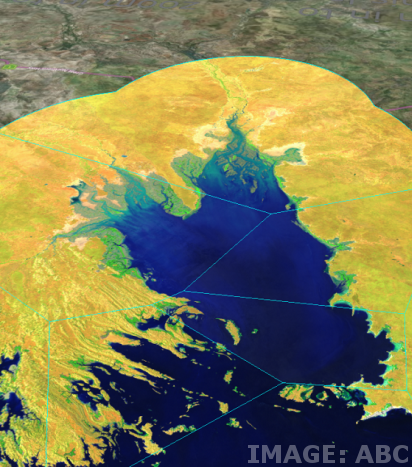 The Murray-Darling Basin Authority (MDBA) has used satellite imagery to monitor possible water theft in the Northern Basin.
The MDBA has accessed free satellite images from the European Space Agency to track water flows in the Barwon and Darling River systems during a major water release into northern rivers in April this year.
The authority ordered a pumping embargo at the time to determine exactly where the water was going.
“We were able to see the water passing down the rivers, filling up water holes and connecting billabongs on the way through,” Mr Williams told reporters.
“And we were able to track that and correlate that with the gauging data all the way down to Menindee.
“We were also able to see what was happening in farmers' dams and paddocks along the way.
“Most of the irrigation in that part of the country is for cotton and typically farmers will pump out of the river when they're allowed to and fill up a big dam and then use the storage in the dam to progressively water crops as they plant them and keep them growing.
“So we were able to actually observe the changes in the dam levels and see what was happening on the properties on the way through.”
The satellite imagery revealed an “anomaly” at one farm, prompting an on-ground investigation.
“We observed the changing of a water level at a dam that looked a bit odd and told NSW authorities what was going on and they sent investigators out,” he said.
“[But] in that case it turned out that the irrigator had pumped into the storage before the embargo and had records to demonstrate that, so that's an example of how this information is useful.
“It doesn't give you a prima facie case for a prosecution or iron-clad evidence that you can take to a court [but] it gives you information that you can then follow up with further investigation.”
The experts want satellite imagery to become a permanent fixture in the MDBA’s fight to ensure compliance.
Federal Agricultural Minister David Littleproud said these new approaches could “bring integrity back to the Murray-Darling Basin Plan”.
“No-one should fear compliance if they're doing the right thing,” he said.
The satellite imagery carves Australia into pixels of about 55m2, and can be accessed by the MDBA within about 12 hours.
“They can actually watch the water coming down the river,” Trevor Dhu, leader of the Digital Earth Australia program, told the ABC.
“And they're going so fast that we get a complete picture of the continent about every week.”
Mr Dhu said there are over 30 years’ worth of images available from the American Landsat satellite.
“So we've got a 30-year baseline that allows all Australians — the public, government, farmers, miners — to look back through time and actually see how that land has changed,” he said.
“And the power of that is just incredible.
“We can see how often lakes have been filled, we can see how green a pasture has been … we can start to look and compare how two neighbouring pastures have performed.
“And in the future farmers will be able to use it to see if different farming practices are actually having long-term productivity benefits for their properties.”