Fire plume forms smoke belt
 Print
PrintNASA says the plume of smoke from Australia’s bushfires has encircled the planet.
NASA scientists have traced the movement of the smoke coming off the Australian fires across the globe, showing that it has circumnavigated the Earth.
NASA’s satellite instruments are often the first to detect wildfires burning in remote regions, and the locations of new fires are sent directly to land managers worldwide within hours of the satellite overpass.
Together, NASA instruments detect actively burning fires, track the transport of smoke from fires, provide information for fire management, and map the extent of changes to ecosystems, based on the extent and severity of burn scars.
The technology can give scientists, firefighters, health experts, local government, and others information about what is happening on the ground in real-time.
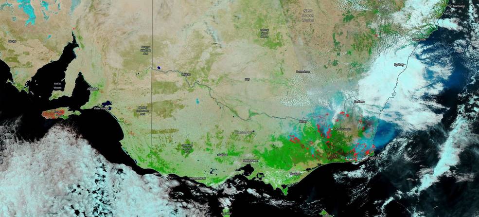
In an image taken on January 13, 2020 (the first of two seen below), NASA’s Suomi NPP satellite used the reflectance bands on the VIIRS (Visible Infrared Imaging Radiometer Suite) instrument to clearly show the areas that have been affected by the fires (dark brown to black) alongside areas not burned (appearing green to bright green).
These reflective bands can also be used to show the “height” of clouds since clouds lower to the ground appear whiter and clouds higher in the atmosphere appear bluer to aqua since the ice crystals within the clouds reflect a bluer colour using this instrument.
Just changing values on a satellite instrument can give those on the ground information they would not have any other way. The image below shows the burned areas, clear areas and clouds in just this way.
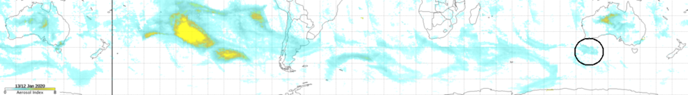
In the final image (created from data gathered by the Ozone Mapping and Profiler Suite [OMPS] Nadir Mapper on Suomi NPP), a black circle shows the smoke which had been traced from its origins coming back to the eastern region of Australia after having travelled around the world.